← All Properties Available Restaurant

🏢 for Lease: 2,871 SF Restaurant in Lantana · #12412

📍 301 E Ocean Ave · 1st Floor, Ste 1-2 · Lantana, FL 33462
🚶 Street View Drag to look around · Scroll to zoom
Quick Unit Specs
2,871 SF Sq Ft
Restaurant Type
Available Status
Listing Type
$30.00 /SF/YR Lease Rate
$7,178/mo Monthly Rate
Negotiable Lease Terms
Lease Type
Asking Price
Price / SF
Cap Rate
Full Build-Out Condition
Power
Central Air And Heating HVAC
Estimated Parking
Yard
Building Specifications
CityLantana, FL
ZIP Code33462
ZoningC1
Year Built1960
Use TypeRESTAURANT
Gross Leasable Area98,307 SF
Total Building SF98,307 SF
Total Available2,871 SF
Land Area70,337 SF
Appraiser SF10,161 SF
Stories1 Floor
Lot Size74,270 SF
Clear Height10'
ConstructionSTUCCO ON MASON
Exterior WallSTUCCO ON MASON
FoundationWOOD FRAME
HVACCENTRAL
Park/Complex301 E Ocean Ave
Space Description & Highlights
Former Law Office. Zoning is now restricted to retail use only.

Highlights:
• Lease rate does not include certain property expenses
• Highly Desirable End Cap Space
• Partitioned Offices
• Emergency Lighting
• Finished Ceilings: 10’
• Display Window
• On Site Parking
• Intracoastal Block
• Fully Built-Out as Professional Services Office
• Central Air and Heating
• Drop Ceilings
• After Hours HVAC Available
• DDA Compliant
• Street Side Retail
• Excellent for Smoke Shop and Other Retail Uses
Building Description
Property Overview
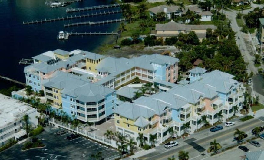
Beautiful Mixed Use Intracoastal Front Project. This space fronts directly on E Ocean Ave and across from the World Famous Old Key Lime House
Trade-area demographics
Population
4,325
Households
1,856
Median income
$62,685
Median home value
$225,000
Walk Score
50
Trade area (1 / 3 / 5 mi)
1 mi3 mi5 mi
Population12,55973,345220,793
Households5,46027,72580,072
Avg income$114,398$87,457$93,138
Household income (purchasing power)
< $50k39%
$50–100k25%
$100–150k25%
$150k+12%
Traffic count (frontage)
41,500 cars/day (AADT)
Nearby: 41,500 · Bridge No-930276 | 16,000 · EAST END BRIDGE 0094

Neighborhood Demographics · Census Tract 005501

Figures for the census tract this property sits in — the immediate surrounding neighborhood (roughly ½–2 sq. mi). For distance‑based totals, see the 1 / 3 / 5‑mile rings below.
4,325
Population
$62,685
Median Household Income
44
Median Age
1,856
Households
$225,000
Median Home Value
Household Income of 1,856 households
<$50k722 39%
$50–100k456 25%
$100–150k458 25%
$150k+220 12%
Age of 4,325 residents
Under 18648 15%
18–341,036 24%
35–541,465 34%
55–64469 11%
65+707 16%

Trade-Area Rings · Distance from Property

Everyone living within a straight‑line radius of the property — the classic retail trade area. Each ring is cumulative (the 3‑mile total includes the 1‑mile).
1 Mile
12,559
population
5,460 households
$114,398 avg income
3 Miles
76,349
population
28,399 households
$86,925 avg income
5 Miles
217,777
population
78,998 households
$93,528 avg income

Frontage Traffic vs. Palm Beach County's Busiest Roads

This property fronts E Ocean Ave. Below, its measured daily traffic (FDOT count) is compared to five of the county's busiest roads — I‑95, Florida Turnpike, Okeechobee Blvd, US‑1/Federal Hwy, and Military Trail (approximate peak AADT) — to show how much exposure the location gets.
41,500vehicles / day on E Ocean Ave (AADT)
I‑95 (interstate) 255,000
Florida Turnpike 95,000
Okeechobee Blvd 62,000
US‑1 / Federal Hwy 46,000
◆ E Ocean Ave 41,500
Military Trail 40,000
This frontage carries about 16% of I‑95's volume — solid commercial‑corridor traffic. County roads shown are approximate peak AADT.
FDOT count stations on E Ocean Ave
41,500 AADT between Bridge No-930276 and BROADWAY (2025)
21,500 AADT (2025)
16,000 AADT between EAST END BRIDGE 0094 and SR A1A/OCEAN BLVD. (2025)
14,700 AADT between US-1/SR-5/DIXIE HWY and EAST END BRIDGE 0094 (2025)
Risk & Incentives
⚠ Flood Zone AE · SFHA ⚠ In Flood Hazard Area Not an Opportunity Zone

Proximity
✈ Airports
Palm Beach Intl (PBI) 10.4 mi 16 min drive
Ft. Lauderdale (FLL) 35.9 mi
Miami Intl (MIA) 56.4 mi
⚓ Seaports
Port of Palm Beach 13.4 mi
Port Everglades 34.8 mi
PortMiami 56.4 mi
Appraiser Data
Parcel Control No.40434503140040011
Building UseRESTAURANT
DOR Use Code2100 — RESTAURANT
MunicipalityLANTANA
SubdivisionLANTANA POINT ADD IN
Assessed Value$3,606,033
Land Value$2,838,017
Improvement Value$616,210
Total Taxable Value$3,606,030
Land UseRESTAURANT
Legal Description
LANTANA POINT ADD
Sale History
Sale 1$418,144 · 07/1994
Source: Palm Beach County Appraiser Records
Lease Rate
$30.00 /SF/YR
Extended Unit Specifications
Suite 1st Floor, Ste 1-2
Available Now
Clear Height 10'
Drive-In Bays
Dock-High Bays
Office SF
Restrooms
Parking Ratio
Op. Expenses
Request Information
Listing Courtesy of Strategic Realty Services, LLC
Christopher Fleming
Strategic Realty Services, LLC